Path to Shelligoe Fishing Station Show path on map
Start location: Shelligoe fishing station ( ND 252 351 )
End location: Lybster ( ND 247 351 )
Geographical area: Caithness
Path type: Trade Route
Path distance: 0.3km
Accessibility info: Suitable for pedestrians
Route Description
Newsflash (January 2019): The Press and Journal reports that one of the two routes down to this old fishing station near Lybster has suffered a landslip, so is likely currently unsafe. The slip affects the route which uses the John o' Groats Trail, so the JoGTrail website helpfully provides a map showing the alternative route down into Shaligoe.
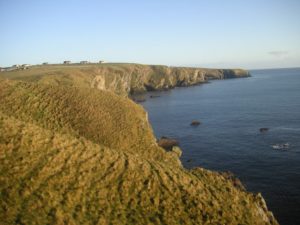
A semi-circular route can be taken from one part of Lybster to another using two old paths connecting via the old fishing station. Just north of the junction of Harbour Road with Main Street, a sign reading "Footpath to Shelligoe Beach" points east along a road through housing. Reaching a kissing gate at ND249353, there is another sign to the beach. This is an easy footpath on a broad grassy bank between ditches and fences with brick-edged drains crossing the track. The path narrows to descend a re-entrant with a stile at ND251351, then flagstone steps descend to a stony beach in a geo in the cliffs (ND251350). Here the strata of sea rocks are near vertical. The return route climbs up flag steps to a stile (ND250350) and to housing along the road "Southend", but it is this route which is affected by the recent (Jan2019) landslip, so we suggest returning by the outward route.
OS Landranger 11 (Thurso & Dunbeath)
Heritage Information
This is an old track leading to the remains of an abandoned fishing station at Shelligoe. The fishing stations were where the Herring boats brought home their catch to be processed. The herring industry was huge in Scotland and gave a lot of jobs to people who had recently been cleared from their homes.
The fishing station at Shelligoe seems to be only the one large building, which would have been used as storage and to cure the herring.
