Paths to Stiomrabhaigh Show path on map
Start location: Orasaigh, Lewis ( NB 361 120 )
End location: Lodan Stiomrabhaigh, Lewis ( NB 367 126 )
Geographical area: Western Isles
Path type: Rural Path
Path distance: 2km
Accessibility info: Suitable for pedestrians
Route Description
A path and steps take you up to the ridge of a hill above Orasaigh (Orinsay), then the route is marked by posts across the moor via Loch Shaghachain to Lodan Stiomrabhaigh.
A longer route starts on the Leumrabhagh (Lemreway) to Orasaigh road, going by Loch Caol and Loch Shanndabhat to Loch Mor Stiomrabhaigh, following its outlet to the former settlement.
OS Landranger sheet 14 (Tarbert & Loch Seaforth)
Heritage Information
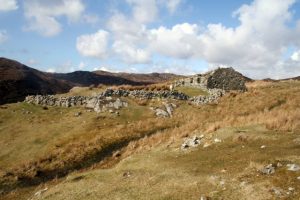
The township of Stiomrabhaigh (Steimreway) was cleared in 1857, resettled in 1922 and finally deserted in 1942. The 1851 census records 81 people in 16 households, but by the 1861census the tenants had been cleared to Leumrabhagh. It remained deserted until after the First World War when the pressure for more crofting land resulted in five families settling there. They were never recognised as official crofters, and gradually people moved away until by the Second World War only two families lived in Stiomrabhaigh. The township became again deserted when Donald Morrison left in 1942.
The route marked with posts is the way that children from Stiomrabhaigh took to get to the school in Leumrabhagh, 3 miles away.
with thanks: Scottish Islands Explorer magazine Jan/Feb2009
for more information: www.angusmacleodarchive.org.uk
