Craik Muir Roman Road Show path on map
Start location: Raeburnfoot ( NY 253 991 )
End location: Craik village ( NT 349 081 )
Geographical area: Lothian and Borders
Path type: Pilgrimage Route, Roman Road
Path distance: 15km
Accessibility info: Suitable for pedestrians, Survey required
Route Description
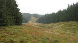
This old Roman road passes through the extensive Eskdalemuir and Craik Forests where notices are displayed denoting sites of historical interest, but forestry activity does mean the old road can be challenging to find and follow. It will be necessary to parallel its former line on forestry tracks for some of the way, but thick vegetation and/or felling/replanting can make passage difficult.
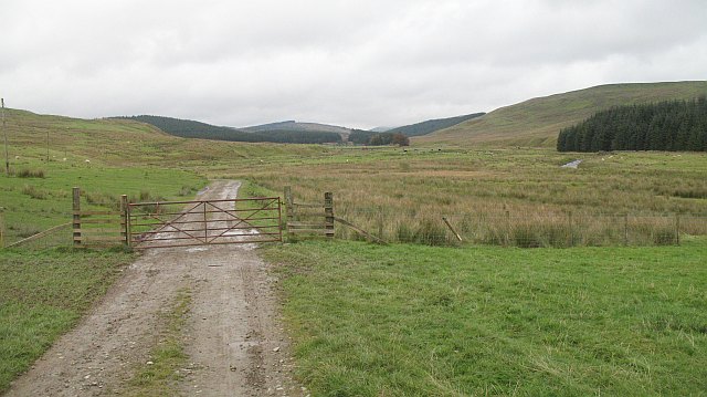
Access to the Roman road can be found from the B709 in Eskdalemuir. At NY255977, east of the bridge over the White Esk, leave the B709 to instead follow a minor road going north on the east side of the river to go over the hill to Raeburnfoot (remains of Roman fort on the left). From there go up the Rae Burn for 2km. The old road leaves the forest track at NT267007, but from here to Craik Cross Hill the route is on heavily overgrown forest rides and may be difficult to follow. The route goes uphill northeast, where there is some evidence of the Roman road, to cross another forest road at NT278024. The Roman Road is then close by and intersects other forest rides (careful navigation is needed to follow it). Continue over Craik Muir and Lamblair Knowe to Craik Cross Hill (449m), the highest point on the route.
Just to the southwest of Craik Cross Hill, the Roman road was joined by the waymarked Romans and Reivers Route (R&RR) it inspired. The R&RR is followed northeast, either on or closely following the Roman road, descending to Northope Haugh (NT335075), an abandoned shieling. Beyond the shieling, the Roman road can be followed with careful navigation to Craik village. Alternatively, stay on the R&RR waymarked broad track which also brings you to Craik.
The R&RR does also offer an alternative start point in Eskdalemuir at NT239016, although this takes about 8km to reach the Roman Road near Craik Cross. As one of Scotland’s Great Trails it should be easier to follow than the section of Roman Road described above. That said, reduced local authority funding for public access provides its own challenges in upkeep for this modern variant to the old route.
For the very keen old route explorer, a further section of this old route is marked on OS maps as continuing southwest from the Raeburnfoot fort. It crosses the White Esk by a marked ford (of unknown quality) to reach the B709, then is marked over first open ground then forestry, eventually meeting the B723 in Castle O’er Forest. How accessible this western section is, is currently unknown by the Heritage Paths project.
OS Landranger 79 (Hawick & Eskdale area)
Heritage Information
Much of this Roman road is a Scheduled Monument. It is said to have been an excellent feat of Roman military engineering - there are lengthy cuttings and terraces where the bedrock has been exposed and used as the road surface. There are also sections of holloway where extensive use has worn the surface of the road down so that it is now several metres below the surface of the surrounding land. This is quite common on very old roads.
The small Roman fort at Raeburnfoot is thought to be Antonine in date. Craik Cross Hill is fascinating because it is the likely site of a Roman watchtower or signal station, but was later reused with a cross marker stone on the hill. This may have been a route used by pilgrims to get to Whithorn, so the cross would have been a sign to guide people there. As it was such a well constructed road it would have made sense to use it as a main route well into medieval times. Indeed, the road has been theorized to be the same road mentioned in a 13th century charter as the royal road from the valley of Annan towards Roxburgh.
D G Moir in "Southern Hill Tracks" conjectures about the possibility of the Roman road originally extending from Craik all the way to Black Craig, Harelaw, and Firth and a possible connection with Dere Street.