Lamb Hoga Peat Road Show path on map
Start location: Tresta ( HU 609 906 )
End location: Moo Wick ( HU 621 877 )
Geographical area: Shetland Islands
Path type: Rural Path
Path distance: 4km
Accessibility info: Suitable for pedestrians
Route Description
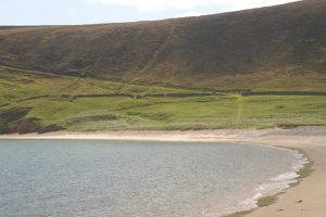
At the church road end, the route is signposted Tresta Beach. Follow the road southwest past the church on its south side where it becomes a track skirting the beach. Ahead the track can be seen as a ledge ascending the hill. A track still crosses the moss of Lamb Hoga. Old maps show its alignment somewhat more to the northeast taking the higher ground and passing over Gillis Field, before heading south-southeast to descend ultimately to Moo Wick.
Heritage Information
This old peat road steeply ascends Lamb Hoga above Tresta beach. The peat found on Lamb Hoga supplied Fetlar and is said to have either been brought down off the hill by ponies or taken off by boat. The old maps which show the route mostly indicate Moo Wick as the likely point from which the peat may have taken to the water, however some show a spur down to Rousker (HU613893).
