Loch Katrine Drove Road from Inverarnan Show path on map
Start location: Trossachs Pier, Loch Katrine ( NN 495 072 )
End location: Inverarnan ( NN 321 187 )
Geographical area: Loch Lomond and Trossachs National Park
Path type: Drove Road
Path distance: 26km
Accessibility info: Suitable for Motorised wheelchairs, Suitable for pedestrians, Survey required
Route Description
Our main route description is given in reverse to the direction the droves would have travelled:
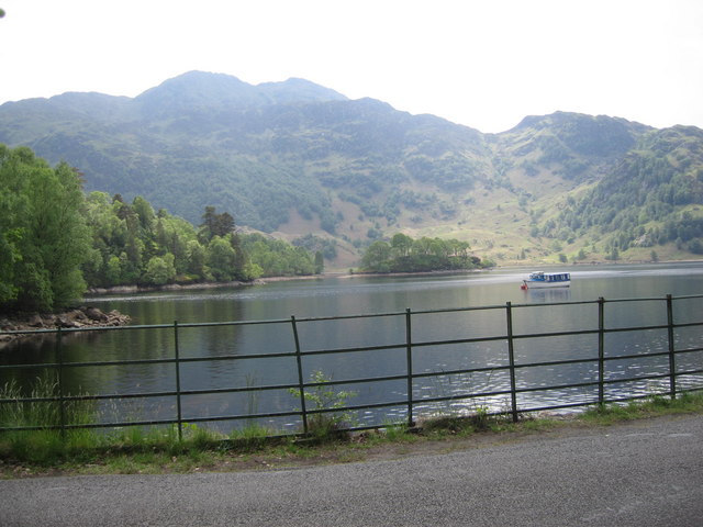
From the Trossachs pier, take the Great Trossachs Path (GTP) for 16km along Loch Katrine‘s north shore to its west end (NN380134). From here, follow the rough track up Glen Gyle below a line of pylons for 3km, then continue beyond the end of the track for a further 2km on the northeast side of the Glengyle Water (indistinct path) meeting the coffin road to Balquhidder en route which is now followed to the col at the head of the glen. Descend northwest down a wide boggy corrie to the confluence with the Ben Glas Burn (NN335177), where there is a mini hydro scheme. Cross here to reach the path on its north side. Follow this down to Beinglas farm and cross the River Falloch to reach the A82, 300m north of Inverarnan and 3km north of Ardlui.
Stronachlachar is an alternative starting point. In spring/summer, there are regular trips from the Trossachs pier by the Loch Katrine steamer Sir Walter Scott, which provides the opportunity both to do a circular route and from the head of the loch be travelling in the same direction as the drovers! From its pier, go northwest along the GTP on the south shore of the loch to its west end, where there’s a choice. Either stay on the GTP following this to the Trossachs pier; 20km/12.4miles in total. Or follow the route to Inverarnan as described above, in which case the total distance is 13km/8miles.
The section along the private road on the north side of Loch Katrine was included in Walking on Wheels, a guide for wheelchair and electric scooter users. At least as far as Brenachoille Point, the route is said to be well-surfaced and reasonably flat and a further 5 miles may be possible although after that there are gradients of more than 1:10. It may be worth noting that deer grids were said to have side gates difficult to manipulate from a sitting position. As there may have been changes since the book was published in 2006, the project would very much welcome any updates as to the route’s accessibility.
OS Landranger 56 (Loch Lomond & Inveraray) & 57 (Stirling & The Trossachs)
Heritage Information
This drove road together with that from Dalmally to Inverarnan was one of the most important drove roads in Argyll. At Inverarnan is the famous drovers’ inn of the 18th and 19th centuries and a favoured hostelry (as the White House) of climbers in the pre-war era. Appropriately enough for a loch in Rob Roy MacGregor country and linked so closely with droving, Loch Katrine's name is derived from the term cateran.
Rob Roy was born at the head of Loch Katrine, at Glengyle, in 1671. The present house post-dates his birth. The setting has changed as the loch now extends further up the glen, the water level having been raised as a result of the Glasgow Corporation Water Works Act 1855 to supply clean water to Glasgow. The Pipe Track (Killearn to Strathblane) follows part of the water's course to the city.