Tain Drove Roads Show path on map
Start location: Edderton Mains ( NH 720 842 )
End location: East Lamington ( NH 753 779 )
Geographical area: Ross and Cromarty
Path type: Drove Road
Path distance: 10km
Accessibility info: Suitable for pedestrians
Route Description
There is a network of old drove roads southwest of Tain.
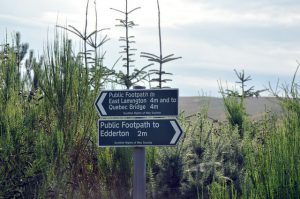
Starting from Edderton on the A9, 6km northwest of Tain, the minor road signposted to Edderton Mains is followed and continues as a track round the west side of Edderton Hill through the Morangie Forest. At Culpleasant (NH743796) the track divides, and the first of three possible routes to the Scotsburn road heads northeast via Rosehill. Continuing south, another junction is reached at NH744793, and from here head to the Scotsburn road by going either east to Quebec Bridge (NH759797), or southeast to East Lamington (NH754779).
There is also a more southerly route through Strath Rory which links the B9176 with the Scotsburn road. Northeast of the B9176’s Strathrory Bridge, the start is signposted at a bend with space for car parking (NH667778). Take the track southeast down the Strathrory River; the route becomes a path which can be boggy and indistinct in places. Pass south of Cnoc an Duin to a derelict cottage at Coag. Continuing east, take a left fork just before Scotsburn House, which leads along the woodland/farmland edge to Dalnaclach (NH733763).
For assistance with exploring the area, The Highland Council have produced a Paths Around Morangie Forest leaflet which suggests various trails.
Heritage Information
These relatively short drove roads are links in the network which led from Caithness and Sutherland to Milton and Kildary. The Lairgs of Tain was a well-known drove road used by drovers avoiding the high tolls on the Struie Road. Dalnaclach was a resting point for drovers at one time as well.
This network probably represents a set of tracks that were used at different times. Some of them may have been used in the 18th century when there was a drovers' Tryst at Kildary near Milton; some may have been used to get to Muir of Ord, which became a very big Tryst around 1820; and they were probably all used by drovers avoiding tolls and other big droves.
