Coffin Road to Balquhidder Show path on map
Start location: Ardcarnaig ( NN 453 186 )
End location: Beinglas road-end, A82, north of Inverarnan ( NN 318 187 )
Geographical area: Loch Lomond and Trossachs National Park, Stirling, Clackmannan and Falkirk
Path type: Coffin Road
Path distance: 15.6km
Accessibility info: Suitable for pedestrians, Survey required
Route Description
Our route description is east to west, i.e. in the opposite direction of travel of the coffins.
One can start by walking an additional 10km/6miles from Balquhidder along the narrow public road on the north side of Loch Voil and Loch Doine to the carpark at its end, ¾km east of Inverlochlarig farm, which is on the site of the house where Rob Roy MacGregor died in 1734.
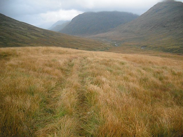
Walk up the glen past the farm on a good track for 5km. Beyond its end continue for 2km beside the headwaters of the River Larig and make a rising traverse on the south side of the river to the Bealach nan Corp (NN360160). This col is broad and boggy and may be confusing in mist.
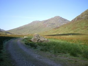
Bear west to pass through a fence at the foot of Sidhean a’ Chatha, then go northwest on a slightly descending traverse across the grassy southwest flank of Parlan Hill, meeting an old drove road (Inverarnan to Loch Katrine), and reaching the col at the head of Glen Gyle where there is a small lochan. Descend northwest down a wide boggy corrie to the confluence with the Ben Glas Burn (NN335177), where there is a mini hydro scheme. Cross here to reach the path on its north side. Follow this down to Beinglas farm and cross the River Falloch to reach the A82, 300m north of Inverarnan and 3km north of Ardlui.
OS Landranger 57 (Stirling & The Trossachs area) & 56 (Loch Lomond & Inveraray area)
Heritage Information
This is a well-known former coffin road going from Glen Falloch to the old church in Balquhidder where Rob Roy is buried. Considering the people who walked the route would have been carrying a full coffin, the distance and height climbed is amazing. It must have been a real relief to them when they got to the atmospherically named high point of Bealach nan Corp (pass of the corpses).
William Roy, in his military survey of 1747-55, marks the road along the south shore of Loch Voil as the principal route to Balquhidder. However, this must have been quickly replaced as the road on the north shore of Loch Voil is the only route depicted in James Stobie's map of the Counties of Perth and Clackmannan (1783). Therefore, the coffin road probably originally went by the south side, but later was replaced by a road on the north shore.