Puilladobhrain Anchorage Track Show path on map
Start location: Clachan Bridge, Seil (B8003), Tigh an Truish Inn ( NM 784 197 )
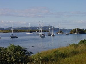
End location: Puill an Dobhrain Anchorage, Seil ( NM 782 202 )
Geographical area: Argyll and Bute
Path type: Rural Path
Path distance: 0.5km
Accessibility info: Suitable for pedestrians
Route Description
From the N side of the Tigh na Truish Hotel, a narrow but well-trodden pedestrian path runs between the hotel and the B&B next door. A Society signs reads: ‘Public Footpath, Puilladobhrain Anchorage’ and an arrow screwed into a large rock reinforces the line. The path passes through bushes for some 200m and emerges into an open area where a gate marks the entrance to a field. At the far / top / west end of the field, old gateposts show where the field formerly ended. The path continues downhill now, with the shore in sight, and a bare pole at the shore indicates (or presumably is intended to indicate) a turn to the right / north along to the usual landing-spot where there is a Society sign reading: ‘Public Footpath, Main Road’.
Heritage Information
Puilladobhrain Anchorage shown on Admiralty Charts as early as 1856 and a track is shown on the charts of that period. Anchorage has continued in use by yachts etc. to present. The path was the only means of access for crews of ships in the anchorage to the village for provisions, fuel and so on.
