Ceann a’ Mhaim Coffin Road Show path on map
Start location: A87, 1km W of Invergarry ( NH 297 012 )
End location: A887, Achlain ( NH 280 123 )
Geographical area: Inverness, Nairn, Badenoch and Strathspey, Lochaber
Path type: Coffin Road
Path distance: 12.2km
Accessibility info: Suitable for pedestrians, Survey required
Route Description
This route is not easy to follow as there is no track on the open hillside.
According to Old Tracks: Cross-Country Routes and Coffin Roads in the North-West Highlands by A E Robertson (1941): “there is an interesting old cut across from Glen Garry to Glen Moriston. It is a ‘coffin’ road and used as such until recently.
The route starts from a place called Seanna-bhaile (old ground) and it goes more or less straight to Loch Lundie and on to near the top of Ceann a Mhaim where the coffin was rested, refreshments partaken of, and a cairn built. A number of the cairns are still seen.
The route then went over the east shoulder of the hill and down to Achlean in Glen Moriston. The graveyard is on the opposite side of the river, and there is a ford below the farmhouse quite close to the churchyard.”
If starting from Glen Moriston, our surveyor suggests using the forest track heading south from Achlain (NH278123). Although this track is shown on the Landranger map as terminating at the overhead lines, it continues south up Allt a Choire Bhuide, crosses to the Allt a Criche and emerges from the forest block at NH269106 onto shallow peaty moorland. Here again, remember there is no visible track on the open hillside.
OS Landranger 34 (Fort Augustus & Glen Albyn area)
Heritage Information
A E Robertson continues: "Here is a quaint tale told me by a Glen Moriston man. His uncle was staying at Invergarry when something went wrong with his leg and he had to have it amputated. His brother came across and carried the leg over Ceann a Mhaim and buried it in the old graveyard where they would all one day rest. This was 46 years ago and shows what store the old Highlanders laid on their being buried, as far, as possible, whole and intact, so that at the resurrection they would arise perfect and entire."
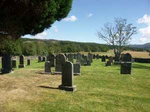
Our records from 1929 state that the graveyard was called Clachan Mheirchard, and it was there that a bell used to ring for a few nights previous to the funeral. It was also said that the stone on which the bell rested was still to be seen in the clachan. According to the New Statistical Account (1846) in Glen Moriston "are St Erchard's seat, well, church and churchyard", and although there is no trace or local knowledge of a church the graveyard can be seen marked on the OS 6" map of Inverness-shire published in 1874. In 1964, the OS reported that this graveyard dedicated to St Merchard was still being used, the oldest inscriptions on the gravestones dating back to the mid nineteenth century. However, it is certainly older than that as the Old Statistical Account (1791-1799) refers to Clachan Merecheard as one of two burying places in Glenmoriston. Another clue to its age may be its near circular shape - elsewhere this has been said to possibly indicate a very early date.
As to the cairns still visible in 1941, although there are two cairns marked in the vicinity of Ceann a' Mhaim on current OS mapping, there is also an unmapped collection of stone rows on its north-east shoulder (circa NH281090). The latter are more likely to be the cairns associated with this coffin road, but despite local knowledge such as that reported by AER, they went relatively undocumented until surveys took place associated with the Millennium Wind Farm proposals, when Headland Archaeology identified 25 cairns measuring 1m high and 1.5m in diameter. The Ceann a' Mhaim Cairn Rows have now been added to the Highland Historic Environment Record (HER) database.
