Old Road to Aith Show path on map
Start location: unclassified road, north of Clodisdale ( HU 507 418 )
End location: Aith ( HU 514 434 )
Geographical area: Shetland Islands
Path type: Rural Path
Path distance: 1.7km
Accessibility info: Suitable for pedestrians
Route Description
The track starts at HU507418 where it leaves the unclassified road to Setter.
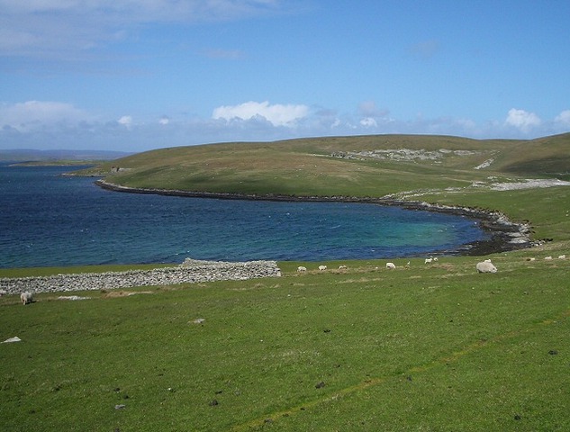
The route is a vehicle track used by farm and other vehicles accessing the still inhabited houses at Swart Houll and Bruntland, but it continues north into a now totally uninhabited peninsula which has a number of interesting relics of the 19th and early 20th century. The vehicle track terminates at Aith (HU514434), but onwards the going underfoot is fairly good.
A walk leaflet is available to download.
OS Landranger 4 (Shetland – South Mainland)
Heritage Information
This old path to Aith, and the peninsula of Aith Ness beyond, provides access to this long inhabited area of Bressay. In the 19th century, Aith was a township containing 7 families who were employed in flagstone quarries in the locality, such as the former quarry at Blue Geo. The flags were used for paving, slating and for building dry-stone dykes. This sandstone paved the streets of Lerwick, and indeed Lerwick Town Hall is built with Bressay stone. The quarries shut in 1864 and the population was cleared in the early 1870s to create sheep farms.
Setter farm was established in 1872, and included the crofts at Aith and Aithness. The 3 crofters - Catherine Nelson (nee Smith), Thomas Smith and John Sinclair - and their families together with the occupants of the other 6 houses had to leave. However, John Sinclair died at Aithness in 1879, so it is thought that he may have had a subtenancy - he is described as a master shoemaker.
These changes in Bressay were brought about by the death in August 1871 of Mrs Margaret Cameron Mouat, the sole owner of the island. The following report appeared in The Saturday Herald & Shetland Gazette on 16th September 1871:
"Last week the tenants in Bressay were given to understand distinctly the terms on which they will be allowed to remain in their present holdings. The conditions are such that the island has been turned into a bochim*. All who are able to remove have resolved to do so at once, but there are few in circumstances to rise and go to a country where the oppressor dare not touch them, an hence the sighing and crying of the bewildered people are painful to hear. They have been active both on land and sea, and, though toiling hard daily, they have lived in some degree of comfort until now that the demise of the last Mouat to whom the property belonged has put them under a new regime, and one which they believe must end in their destruction, though attempts are made to persuade them that it is only for their benefit. This is much like the boy who while pelting the young ducks, kept saying, “It’s all for your good, little duckies, it’s all for your good”, only that the people of Bressay have enjoyed the benefit of getting a good common education for a number of years back, and are fully as well qualified to judge of what is for their good as the individual who now professes to enlighten them. When the poor peasants are prevented from having a sheep in the pasture, or a quey or cow outside the dykes, how is it possible they are to keep their crofts, or live on them? At the corners of the houses here in town, many of them may now be seen standing crying, and telling their sad tale, enough to make any heart softer than steel to bleed. A day of retribution will surely come, and it may not be very distant either. (*n.b. Bochim – Judges 2, Chapter 1.)" [with thanks to Bressay History Group]
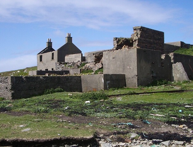
On the shore at HU508439 is the remains of a fishing station / whale factory which closed in 1928. The first edition OS 6" map surveyed 1877-78, has a school marked at Swart Houll to the south of Bruntland. It is unclear whether the schoolhouse predates the Education Act of 1872, any further information about this or the fishing station would be greatly appreciated.
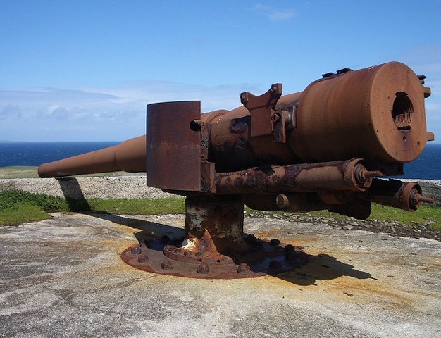
Further north on the peninsula, on the higher ground, are some military gun emplacements dating from the first and second world wars. At HU514446 a naval gun is still in place dating from the first world war, there is also a subterranean magazine with its access trench, the ruined remnants of the gun crew's accommodation block and the remains of a winch for installing guns and landing stores.