Old Path to Symbister Show path on map
Start location: The south end of the road on East Burra ( HU 377 312 )
End location: Houss Ness ( HU 373 299 )
Geographical area: Shetland Islands
Path type: Rural Path
Path distance: 1.7km
Accessibility info: Suitable for pedestrians
Route Description
This path starts at Houss at the south end of the road on East Burra. It follows a vehicle track down to Ayre Dyke, a shingle bar joining the peninsula of Houss Ness to the rest of the island. A path is signed to a viewpoint on the Ward of Symbister, but the track continues almost due south to reach the abandoned croft of Symbister. The going underfoot is marshy and rough in places but is easy to follow as quad bike tracks run all the way to the now ruinous buildings.
OS Landranger 4 (Shetland – South Mainland )
Heritage Information
In 1882, the first edition of the OS 6" map showed a farmstead comprising 5 roofed buildings and 3 separate unroofed buildings, one of which is thought to have been a mill. Symbister croft was abandoned in the 1950s, but might still have been inhabited if money had been found to connect it by road to Houss.

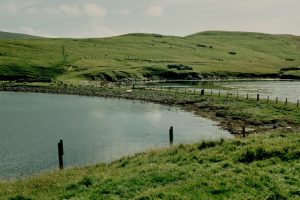
![Symbister. This croft was abandoned in the early 1950s largely because there was no road to it. [Peter Guy, 'Walking the Coastline of Shetland, South Mainland', Shetland Times, Lerwick, 2000]. © Peter Wyatt , Geograph](https://scotways.com/wp-content/uploads/2022/05/Old-Path-to-Symbister-1.jpg)