Kirk Road Show path on map
Start location: unclassified road, north of Tulkie, Mainland ( HU 342 490 )
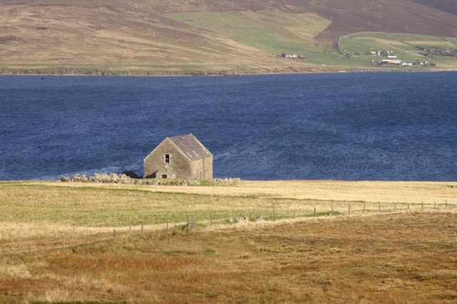
End location: old church on the shore, The Firth, Mainland ( HU 335 504 )
Geographical area: Shetland Islands
Path type: Rural Path
Path distance: 1.5km
Accessibility info: Suitable for pedestrians
Route Description
The track leaves the unclassified road and runs northwards along the shore of Semblister loch before descending towards the shore where the church is located. The route is signposted by the council, from the start point. It is easily followed, as it is used by farm vehicles, but is usually pretty muddy in places, so boots would be recommended.
OS Landranger 3 (Shetland – North Mainland)
Heritage Information
In the late 18th century it was decided to relocate the church from its traditional location at St Mary's Chapel in Sand to a more central location. The graveyard remained at the old chapel site. "A Topographical Dictionary of Scotland" by Samuel Lewis (1846) says about this kirk in the parish of Sandsting and Aithsting, "The church was built in 1780, and reseated in 1824, and contains sittings for 437 persons. Previously to its erection there was a church in each of the two districts; and the present edifice was raised in a central situation, for the more regular performance of divine service; but it is found inconvenient for general attendance, many of the inhabitants being separated by a marshy tract seven miles across, and others by two arms of the sea."
In the 19th century, splits in the church led to the building of a church in Sand not far from the old chapel. In the 1950s the Semblister church was abandoned, it has lain derelict ever since, but until at least recently the pulpit was still standing.
The route is used regularly by farm vehicles, but also by fishermen accessing Semblister loch. Few continue down to the old church.