Portachoillan Ferry Road Show path on map
Start location: Jetty, Portachoillan, West Loch Tarbert ( NR 759 580 )
End location: Quinhill ( NR 765 566 )
Geographical area: Argyll and Bute
Path type: Rural Path
Path distance: 1.6km
Accessibility info: Suitable for pedestrians
Route Description
From the jetty at Portachoillan, the old ferry road runs SSE to its junction with the old line of the Lochgilphead-Campbeltown Road, half a mile north of Clachan. There is a well-used diversion off the old road’s historic line near its north end to avoid a new building known as Ferry Cottage – this is designated as a core path by Argyll & Bute Council and forms part of a local walk known as the Dunskeig circular.
OS Landranger 62 (North Kintyre area)
Heritage Information
Argyll County Council's 1964 List of Highways includes the Portachoillan Ferry Road (No 23) on its list of unclassified roads for the District of Kintyre, however there is no ferry today. The importance of this old road to Portachoillan, rather than that now used via Corran, is evidenced by the OS 6" map (surveyed 1898, published 1900) which marks on it a mile post stating "Tarbert 11 1/2, Campbeltown 28".
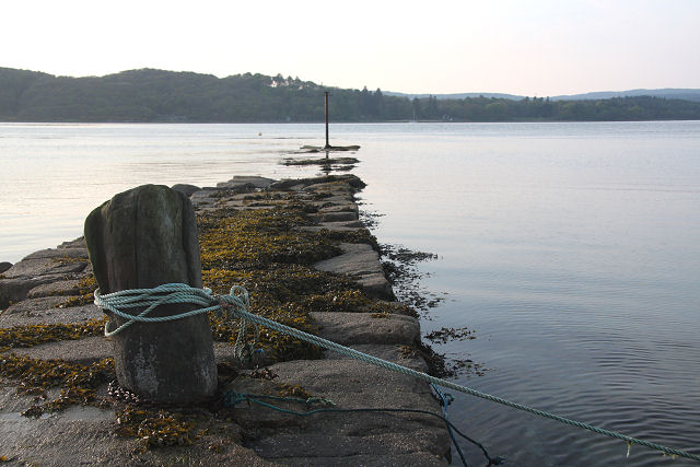
The ferry used to cross West Loch Tarbert from the jetty at Portachoillan to where the OS 1:25k still marks Ferry House and a pier on the far shore. The earliest map showing the Portachoillan ferry road which we have so far located is George Langlands' of the district of Kantyre in Argyllshire (1793), and although it does not mark the ferry, it does show a Ferryhouse on the far side of the loch. However, Langlands marks Ferry on either side of the loch on his 1801 map, along with again showing the Portachoillan ferry road. The ferry route itself is marked on the Admiralty Charts of Scotland for West Loch Tarbert, surveyed in 1849 and published 1856. On the south side of the loch, as well as the jetty at Portachoillan, the north end of our ferry road can clearly be seen. On the north shore, there's a jetty where Ferry House stands today and a Boat House just to the west at Leac Dhubh Earrainn.
Documentary evidence for the ferry here though stretches back further than the mapping; official records appear to start in 1775. It was a vital link for church attendance, as the former parish of Kilberry and Kilcalmonell lay on both sides of the loch, yet there was no church on the north side until 1821. Even once the Kilberry church was built, the minister still needed to cross the loch to preach. Aside from religious traffic, it seems that livestock was carried across here - cows, bulls, calves and pigs - which provides a different image of the use of the ferry road. In 1891's Schedule of Ferries, the ferry boats were described as clinker-built rowing and sailing boats of 15-18ft keel, and also 14ft rowing boats. This was a larger ferry than that at Dunmore further up West Loch Tarbert. The mail and the doctor also crossed the loch here, and the Portachoillan ferry also serviced the Islay steamer. The ferry road must have been relatively busy until the ferry's use ceased in the 1950s. A wealth of historical detail about this ferry route is contained in Walter Weyndling's highly recommended book Ferry Tales of Argyll and the Isles (Birlinn, 2003).