Banton Loch Path Show path on map
Start location: SW corner of Banton Loch ( NS 735 782 )
End location: Craigs ( NS 747 788 )
Geographical area: Strathclyde and Lanarkshire
Path type: Industrial Path
Path distance: 4.5km
Accessibility info: Suitable for pedestrians
Route Description
Newsflash! The Heritage Paths (Campsie Fells) Project is very pleased to announce that we have a lovely Campsies map leaflet showing this old path and other routes in the area. To get your hands on one, simply send head over to our shop.
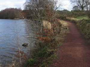
This route starts along a rough road for 0.2km then crosses a footbridge over the Forth and Clyde Canal exit feeder. It follows the south bank of Banton Loch in an easterly direction and continues to a minor road 0.5km southwest of Banton village.
OS Landranger 64 (Glasgow)
Heritage Information
This path is said to have been used by millworkers living in Kilsyth and working in Banton Mill. As such it must have been very busy with many people walking it twice every day. The OS 6" first edition map (surveyed in 1859) shows the path heading along the south shore of Banton Loch, which is marked Townhead Reservoir (Forth and Clyde Canal Co). It meets the road to what was then Low Banton just as it does today and a little further on can be seen the Powerloom Factory.
Townhead Reservoir was built in 1770 to supply water to the Forth and Clyde Canal and at that time it was Scotland's largest reservoir. An worthwhile extension to the Banton Loch Path is to follow the Avenue towards the canal towpath.
Interestingly, Banton Loch is the site of the Battle of Kilsyth. The OS 6" map mentioned above annotates Townhead Reservoir thus: Site of Battle betwixt the Covenanters under General Baillie and the Royalists under the Marquis of Montrose (15th August 1645). The battle also left its mark in nearby place names such as Slaughter Howe, Baggage Knowe and Bullet Knowes.
