Strathkelvin Railway Path (North) Show path on map
Start location: Opposite Strathblane Parish Church, A891, Strathblane ( NS 564 794 )
End location: A803, Kirkintilloch ( NS 656 743 )
Geographical area: Campsie Fells, Stirling, Clackmannan and Falkirk, Strathclyde and Lanarkshire
Path type: Railway Track
Path distance: 12.4km
Accessibility info: Suitable for bikes, Suitable for pedestrians
Route Description
The Heritage Paths (Campsie Fells) Project is very pleased to announce that we have a lovely Campsies map leaflet showing this former railway line and other old routes in the area. To get your hands on a paper copy, simply send us an SAE c/o ScotWays (see address top-right) and we'll post one out to you.
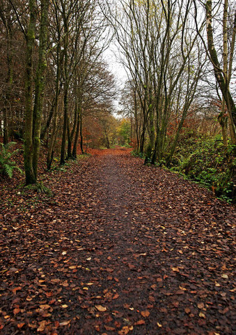
Opposite Strathblane Parish Church on the A891, a signposted path heads south, just east of the Manse. This narrow track leads down to the former railway line, which the route joins, turning east and crossing a bridge. The route continues in an easterly direction along the disused line, passing under a bridge where an unofficial path on to the track leading to Muirhouse Farm is established on the cutting. The route continues east then southeast, passing the volcanic plug of Dunglass on its north side, to a point where the dismantled railway continues into the former Strathkelvin District, now part of East Dunbartonshire.
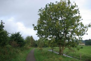
The track is very straight, about 3-4ft wide, tarmacced and bordered by occassional willow and low birch. It crosses the Pow Burn several times and becomes lined with blackthorn, hawthorn and dog rose before passing under a stone bridge carrying an access road from the A891 to a farm. It is more open now with a forest of trees only up high on the right. Another access road is crossed from the A891 to a farmer's lodge. There are open fields on the left and the woods of Lennox Castle on the right. The Pow Burn joins the Finglen Burn and there is a footbridge over the latter. We come now to a triple fingerpost where a narrow path goes off left following the Glazert to Haughhead and Clachan of Campsie. We cross the Glazert by a footbridge to the main drive of the former Lennox Castle hospital. Across the drive is a slip through gate to continue. At this point the route is very close to the A891. The track follows the Glazert mainly on the right and there are a few old metal seats at intervals. The path is also now wider – about 6ft. It goes under a bridge giving access to the former hospital and then another carrying Station Road over at Lennoxtown where there is also an access point. The track goes through a slip through gate alongside a football field on the left to a junction left for Lennoxtown but we continue following the Glazert crossing it by footbridge until nearing Glazertbank Rd where it has become 9-12ft broad and tree-lined. Again slip-through gates and footbridge until it reaches the B822 where a fingerpost points to Milton of Campsie. Once through a slip-through gate, the track continues past Lennoxlea Cottage.
Just after the next footbridge a track goes right towards Red Moss. On the left is a lined path up to Valleyfield, but our track continues across the footbridge. There are flights of steps on the right giving access to playpark and houses on Campsieview Road. There is now a stretch of tarmac through a slip through gate, under a road bridge to platforms where Milton of Campsie station used to be.
Ignore path to play area on right and a loop of river on the left, but keep straight on. There is an access on right up to another old railway line (Kelvin Valley Railway) which leads to Birdston Road, but we continue through the former railway bridge, past some seats following the Glazert all the way. Near the River Kelvin's confluence with the Glazert Water it is crossed by a footbridge. The path continues then down a few steps to a piece of stone piles which would originally be a bridge carrying the railway over the A803 in Kirkintilloch.
Another section of the Strathkelvin Railway Path can be picked up further south in Kirkintilloch. The route restarts opposite Gallowhill Road's junction with the Lenzie/Kirkintilloch Road (B757). Although it is signposted to Moodiesburn, the Strathkelvin Railway Path can actually be followed all the way to Avenuehead Road at NS701697.
The Strathkelvin Railway Path is used in part by the John Muir Way which as of 2014 runs from Helensburgh to Dunbar. Weaving its way through lowland Scotland, this 215km trail also takes in parts of the Stoneymollan Road, the Gowk Stane Road, the Forth & Clyde Canal, the Antonine Wall and the Union Canal. Additionally, this former railway forms a large part of the Thomas Muir Heritage Trail which runs from Clachan of Campsie to Bishopbriggs.
OS Landranger 64 (Glasgow, Motherwell & Airdrie)
Heritage Information
This northern section of the popular Strathkelvin Railway Path has its origins in the Campsie Branch of the Edinburgh & Glasgow Railway and the later Blane Valley Railway.
The Campsie Branch opened on 5th July 1848, running from Campsie Junction (now Lenzie) via Kirkintilloch and Milton of Campsie to Lennoxtown. The Blane Valley Railway was built in the 1860s as an extension to the Campsie Branch. It ran from a new Lennoxtown station via Campsie Glen, Strathblane and Blanefield to Killearn. When the line was again continued, by the Strathendrick and Aberfoyle Railway*, to join the Forth & Clyde Railway, Killearn station was renamed Dumgoyne. Today's Strathkelvin Railway Path (North) had become an essential part of rail services from Glasgow to Aberfoyle. The line was closed to passengers in 1951, but sections continued to be used for freight for more than a decade.
Blane Valley Railway:
Strathblane station had one platform and a loop, which typically handled coal traffic for local homes. To the west the eastern abutment of the bridge which carried the line over the now realigned A81 can be seen. It is said that, when the cutting was being made for the Blane Valley Railway in 1861, an immense deposit of human and horse bones was found a few hundred yards east of the Strathblane manse.
A siding was built at Dunglass to handle material quarried from this basalt plug. Campsie Glen station (NS 61512 78647) was located to the east of where the Finglen Burn meets the Glazert. It is said to be hard to find any remaining traces. Another siding was built during the the First World War to add access to Lennox Castle Hospital. The site of the new Lennoxtown station has been landscaped, but a road bridge remains to the west. It was a single platform station, with the platform on the north side. Only the remains of two bridges mark the site of Lennoxtown Junction - the single-track bridge being the start of the Blane Valley Railway, the double-track bridge once led to the Campsie Branch's original Lennoxtown station and the goods yard.
Campsie Branch:
Lennoxtown (Old) was the original terminus of the Campsie Branch; the site is now parkland. Between Lennoxtown Junction and Milton of Campsie there were sidings for the Campsie alum works and the Underwood chemical works, along with track beds at Lillyburn. The platforms at Milton of Campsie station can still be seen; remains of the buildings can be found to the east of the road bridge and in the undergrowth to the west are the uprights for a station sign. The Campsie Branch was crossed by the Kelvin Valley Railway on a metal overbridge near Birdston; south of this bridge a short spur ran from Kelvin Valley West Junction to reach the higher line at Kelvin Valley East Junction. The spur was used by passenger trains from the high-level Glasgow Queen Street travelling to Kilsyth via Kirkintilloch and by coal trains for the Lanarkshire steelworks.
[With thanks to www.railbrit.co.uk and www.canmore.rcahms.gov.uk]
*Some further information about the Strathendrick and Aberfoyle Railway can be found here: http://www.heritagepaths.co.uk/pathdetails.php?path=246.
The narrow track which leads down to the former railway line at the start of the route in Strathblane is Vicarland Lane. The Old Parish Church Manse used to lie south of the Blane Water - Vicarland Lane linked the kirk and the manse, then continued over the Blane Water to the hairpin bend on the A81 Milngavie Road. Once the railway was built to Strathblane, the lane became a local access from the Campsie Road (A891) to the railway station.